Grids
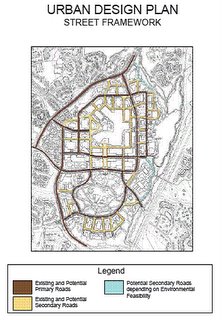
Let’s look at the proposed “Urban Design Plan Street Framework”:

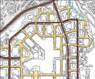
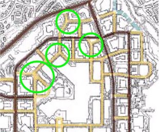
Look at the number of zigzags and dead end streets are on the north end of downtown under the plan:
How will a driver navigate these interchanges and many others (if I added green circles for each problem intersection they would block out the street framework)?
The more changes of roads a driver must make the harder it is for drivers not familiar with the area to find their way to where they are going. As we all know people from outside Columbia are constantly complaining of getting lost in Columbia. Will a grid system fix this? Not if it is made up of short non-through streets that people have to zigzag. I count at least a dozen streets that are only one block long and that doesn’t count the two or three block long streets. Then there are the Y-shaped intersections that will confuse drivers.

Little Patuxent Parkway is still the only north-south road that doesn’t require additional turns.
The only new east-west through street is the Corporate Boulevard.
Will this plan really satisfy the “grid” concept to achieve the results of the consultant’s theory?

3 Comments:
tory burch sale
hollister shirts
oakley sunglasses
true religion jeans
longchamp outlet
michael kors wallet sale
kate spade outlet
tory burch outlet online
links of london jewellery
mac cosmetics
michael kors outlet online
lululemon pants
roshe run men
swarovski crystal
uggs outlet
oakley canada
fitflops uk
tiffany and co
cheap soccer jerseys
michael kors outlet online
0104
atlanta falcons jersey
baltimore ravens jerseys
jerseys wholesale
yeezy shoes
moncler jackets
cheap nike shoes
oakley sunglasses
coach outlet online
pandora jewelry
texans jerseys
Thank you, for getting something new and saluting the irrationality of this story, hopefully it will be useful, so that this life is more useful and useful for others. Cara Mengatasi Nyeri Pundak Cara Mengatasi Batuk Disertai Sesak Cara Mengobati Parotitis Cara Mengatasi Gejala Tipes
Post a Comment
<< Home